Vessel information
Operational information for arrival planning, pilot transfer and manoeuvring at the Port of Motril.
Pre-arrival preparation.
Keep ETA updated and report the vessel’s condition and intended pilot transfer arrangement in sufficient time. Any limitation affecting propulsion, steering, thrusters, draft or manoeuvrability should be communicated before the service begins.
Contact the Pilot Station on +34 636 477 115 approximately 1 hour before arrival at the port.
Maintain a listening watch and coordinate the service with the Pilot Station.
36° 42’ 6’’ N · 3° 31’ 00’’ W, as published in the 2026 PPP.
Prepare the pilot transfer arrangement in accordance with current SOLAS requirements and applicable IMO provisions and recommendations.
Have the information required for a complete Master/Pilot exchange ready: drafts, propulsion, steering, thrusters, tug requirements and any relevant vessel limitations.
The Port Authority’s current technical page states a 100 m channel width and mud seabed. Other official Port publications show 259 m and sand. Before a specific manoeuvre, verify the applicable particulars through current official nautical publications and, where appropriate, with the Port Authority and Pilot Station.
Measured wind at the Port of Motril
Real-time data from Motril2 · REDMAR 3543, operated by Puertos del Estado. The chart shows mean wind speed, maximum gust and wind direction measured at the port station.
Instrumental information subject to Puertos del Estado quality control. It does not replace communications, instructions or operational procedures applicable to a manoeuvre.
Safe pilot transfer.
Pilot transfer is a critical phase of the operation. The boarding arrangement must be correctly rigged, illuminated and attended, with safe deck access and direct supervision by a responsible officer.
Pilot ladder arrangement reference
Reference diagram to support pilot transfer preparation. The vessel’s actual arrangement must always be checked against current SOLAS and IMO requirements.
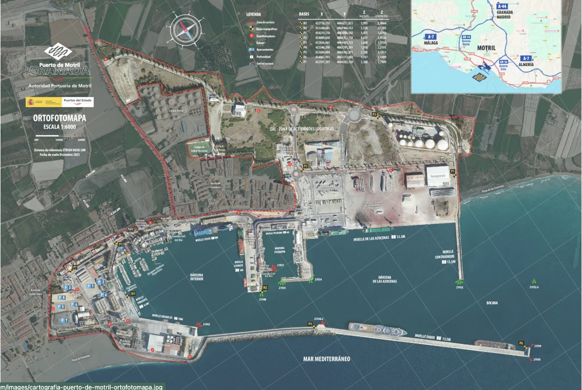
Visual identification of berths, basins and access routes.
The orthophoto provides a quick visual reference for the main basins, berths and landside access routes within the port area. It must not be used as a navigational document; published depths, restrictions and operational conditions should always be verified before each port call.
Published berth dimensions and depth data.
The table summarises berth dimensions and depth data published by the Port Authority. “Maximum vessel draft” is a published reference value and must not be interpreted as an instantaneous sounding, available UKC or operational clearance for a particular vessel.
| Berth | Length | Depth | Max. vessel draft | Main use |
|---|---|---|---|---|
| Costa | 299 m | 8.00 m | 7.6 m | Ro-Pax |
| Levante | 284 m | 8.00 m | 7.6 m | Ro-Pax |
| Poniente | 107 m | 7.30 m | 6.4 m | Bulk / passenger |
| Graneles | 260 m | 10.00 m | 9.2 m | Bulk / general cargo |
| Dique | 860 m | 13.50 m | 12.0 m | Passenger / bulk / general cargo |
| Azucenas | 607 m | 13.50 m | 12.0 m | Ro-Pax / bulk / general cargo |
| Contradique | 252 m | 13.50 m | 12.0 m | Liquid bulk |
| Fishing harbour | 458 m | 4.50 m | 4.0 m | Fishing / aquaculture |
Bathymetry available for technical consultation.
The November 2023 bathymetric survey is provided in its original format, with direct access to the sheets of greatest operational interest so that soundings and contours can be reviewed at adequate resolution.